Bentara Ganga Right Bank Scheme is divided in to Sections namely Meegama & Ittapana. The land area covered by the both Ittapana & Meegama Sections of Bentara Ganga Right Bank Scheme is 1110 ha.
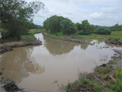
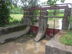
There are damaged Structures and gate in the Scheme. There were one hundred and fifteen gates to operate automatically during high tide and floods in the Bentara Ganga Right Bank Scheme. Some of the gates are damaged and they are to be replaced under this project. In the scheme, flood bunds have lowered their side slopes and have washed away and the channel bund roads have been damaged. Immediately correction action is taken under this project in order to sustain the structures gates and bunds to achieve the desired objectives.
The main task of the project is to prevent floods and intrusion of salt water by improving the drainage and irrigation facilities for the extent and improving the standards of living of the people in the area.
As a summary following items are to be improved and implemented under the Improvements to Bentara Ganga Right bank Project. Physical Progress of the items are mentioned Below.
| Item | Physical Progress |
| Desilting of main and secondary canals with Grab Dredger and pontoon arrangement.
|
40%
|
| Jungle clearing of the canal reservation.
|
40%
|
| Repairs and raising of existing bunds inclusive of breach filling whenever necessary. Considering high tide and normal flood condition raising the bund accordingly.
|
10%
|
| Repair and replacing of gates.
|
30%
|
| Repairs to existing field office at Meegama & Ittapana.
|
100%
|
| Sojan cultivation | 100% |
• Clearing of Irrigation area.
• Construction of community centre at Ittapana
• Construction of cattle crossings and tractor crossings where necessary.
Allocation for the year 2016 is Rs.50.00 million. Cumulative physical progress to end of July 2016 11% and expenditure up to end of July 2016 was Rs. 31.34 mn.